 Home
Home in the ribbon. in the ribbon.
|
| Home |
Metadata++ - Setup: Maps |
| in the ribbon.
|
|
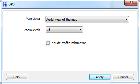
Map View Aerial view overlays satellite imagery onto the map and highlights roads and major landmarks for easy identification amongst the satellite images. Birds eye view tends to be from above, but at a flying height of a bird, so object/people are larger, and there is angle perspective. Aerial view is typically from airplanes or satellites and are much smaller/larger scale with less angle perspective. Zoom level Defines the level of zoom to apply to the view, from 1 (no zoom) to 20 (zoom max). Include traffic informations Displays traffic information overlaid on the roads. |
|
| Even if the camera app embedded the wrong location into your picture files, you can manually adjust the coordinates with Metadata++. See Modifying GPS metadata with Metadata++ |